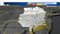
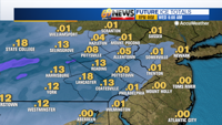
TODAY: Cloudy with periods of light snow arriving this morning, gradually mixing with and changing to sleet and freezing rain. A coating to 1” of snow and a glaze of ice for most; 1-3” of snow in the Poconos. High: 32
TONIGHT: A little snow, ice, or rain tapering back to drizzle or freezing drizzle. Low: 30
WEDNESDAY: A lingering flurry in spots in the morning; otherwise, milder with clouds breaking for some sunshine. High: 41 Low: 25
After a blustery, cold, but dry weekend, we finally got a break from the biting and brisk breezes on Monday. But in exchange, sunshine gave way to increasing clouds as the day progressed, ahead of our next weather maker.
And yes, a storm system we talked about since last week is still on track to impact us today with a round of winter weather. But no, a major winter storm is not expected. In fact, it’s more of a nuisance event with a round of light snow, then an on-again, off-again light mix of sleet, freezing rain, and rain.

Only minor accumulations of snow and ice are expected, but remember, it doesn’t take much especially when it comes to ice to create some localized slick travel.
Once this weakening and rather disorganized system departs, we’re left with mainly dry weather the rest of the week. A briefly milder Wednesday will give way to another shot of noticeably colder and windier weather later this week. While a fairly strong coastal storm will organize east of the Carolinas midweek, it should stay safely out to sea well to our south and east. Our next opportunity for winter weather would come late in the weekend or early next week with the next storm in the pipeline, although track and strength of course remain uncertain at this juncture.
DETAILED FORECAST
TODAY

Our disorganized storm will spread moisture over the region today, in the form of a light mix of snow, sleet, and freezing rain.
Expect any real steady precipitation to arrive not until later in the morning, perhaps not until the morning rush has all but wrapped up. As temperatures climb to around freezing, areas of light snow will mix with and changeover to pockets of light sleet and light freezing rain by the time we get to midday. South of Interstate 78, the precipitation will change to plain rain by midday and stay that way for the rest of the day.
Precipitation should be light and intermittent, but a coating to an inch of snow and a 0.10” or less of ice (freezing rain) is possible across the area, with perhaps a few inches of snow in the higher elevations of the Poconos and far northwestern New Jersey.

The light amounts of snow shouldn’t be that problematic, but it only takes a little freezing rain and a light glaze of ice to cause issues, so be wary of some slick travel, especially in areas where freezing rain is dominant.
TONIGHT
Our light wintry mix will gradually taper away later in the evening, however, stagnant low-level moisture left behind will aid in the development of drizzle or freezing drizzle. This will likely continue for a while overnight.
We’ll need to continue to watch for some slippery spots, although any main roads and certainly anything that has been treated should be ok. Overnight lows will only drop to around 30 degrees.
WEDNESDAY
This will be the nicest overall day of the week, temperature-wise and weather-wise. Expect a one-day warm up into the low 40s as clouds and perhaps a lingering flurry or two early to give way to some milder sunshine. While there will be a bit of a northerly breeze behind our departing storm, it shouldn’t be too excessive, no worse than 10-15 mph.
THURSDAY THROUGH SATURDAY
A strong ocean storm will develop well off the Mid-Atlantic coast, too far away to provide any snow for us. However, it will help to drag down a blast of arctic air as it departs. While the core of the cold will settle into New England, we’ll certainly feel the chill as well, with some gusty north to northwesterly breezes delivering the cold air Thursday into Friday, with the cold lingering into Saturday as well but with lighter winds.
Expect highs to only be in the low 30s on Thursday, with even a rare (for this winter) few days when highs are stuck in the mid to upper 20s Friday and Saturday with colder wind chills all the while. Overnight lows will drop deep into the teens each night. Weather-wise, expect a good deal of clouds on Thursday then increasing sunshine despite the cold Friday and Saturday.
SUNDAY AND MONDAY
The cold will ease late in the weekend and early next week, as our next window for some wintry weather heads our way. At first glance, the set up looks favorable with a cold high pressure to our north over Canada and a storm passing by to our south and possibly reorganizing off the coast. But we’ve learned this winter that things have to come together just perfectly for a bigger storm, as the pieces can always stay separate and miss us if the timing is off.
At least there’s something to watch in the long term, but whether or not it pans out remains to be seen.
TRACK THE WEATHER:
"later" - Google News
January 26, 2021 at 05:00PM
https://ift.tt/3okT4MU
Snow arrives later Tuesday morning, then changes to freezing rain during the day - WFMZ Allentown
"later" - Google News
https://ift.tt/2KR2wq4
Bagikan Berita Ini


0 Response to "Snow arrives later Tuesday morning, then changes to freezing rain during the day - WFMZ Allentown"
Post a Comment